Mineral Exploration Database Management System (MEDMS)

Centralize, simplify & streamline mineral exploration data

Cloud-Based Data Management | Real-time Analytics | Automated Reporting

Overview

Simplify exploration, accelerate decisions

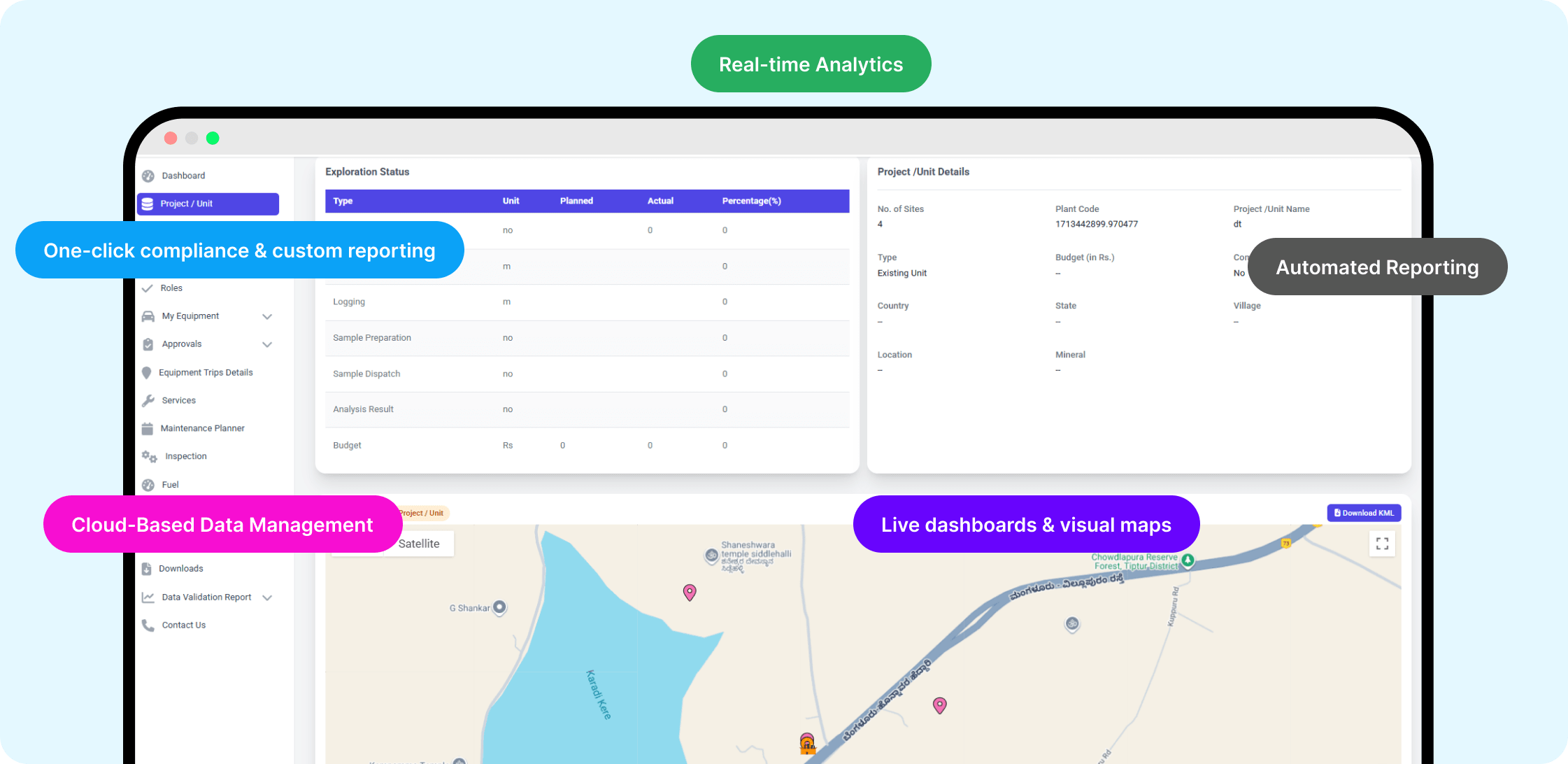
MEDMS centralizes exploration data (collar, borehole logs, assay results etc) securely online, converting offline and scattered records for easy access and collaboration.
Real-time dashboards with borehole geo-mapping enable informed decisions. It efficiently handles large data volumes, automates validation and statutory reports (Form J), and simplifies document uploads, downloads, and version control.

With advanced data analytics and report generation, it supports companies in planning exploration programs, developing mining strategies, and making informed investment decisions.

Features

AI-powered intelligence at your fingertips

Conversational intelligence

Ask complex questions in plain language. No code or data science degree required.

Expert maintenance assistant

Empower technicians to troubleshoot issues instantly by asking for repair procedures, failure histories, or parts information.

Rapid geology & exploration analysis

Enable geologists to ask the AI to correlate drilling logs, seismic data, and chemical analyses to pinpoint high-value deposits in seconds.

On-demand operations insights

Allow managers to diagnose production issues instantly by asking "What caused the downtime on Line 3?"

Instant safety & compliance access

Retrieve any safety protocol, compliance document, or training record with a simple question.

Verified, trustworthy answers

Build confidence with source-linked verification. Every answer is tied directly to the source data or document.

Process

How it works

The InstaDigin system helps geologists manage all their exploration data in one place, making the entire process faster, smarter, and more secure.

Step 1

Upload everything in one place

Geologists upload collar locations, borehole samples, lithology logs, assay results, and KML geo-maps from mobile or web into a single cloud system, eliminating scattered files.

Step 2

Automatic error checking

The system automatically flags issues like missing values or mismatched depths, ensuring clean, reliable data from the start.

Step 3

Secure team access

Role-based access allows geology, mining, and environment teams to securely view data and dashboards. Raw data can also be exported for analysis in Surpac or QGIS.

Step 4

One-click reports

Generate government reports (like Form J) and schedule custom reports with a single click—saving time and ensuring compliance.

Step 5

Visual maps for easy understanding

View all exploration data on intuitive maps, helping teams understand field activity and make informed decisions quickly.

Benefits

Centralized, secure, and effortless data management

Live dashboards & visual maps

Dashboards at both company and project levels, including graphical borehole logs.

Automatic data validation

Built-in checks flag missing values, mismatches, other errors on upload, guaranteeing clean, compliant data for analysis.

Instant, role-based accessibility

Head-office and site teams can view, download, and share live data anywhere, ensuring synchronized, informed decisions across locations.

Unified & secure cloud platform

Unifies collar, borehole, assay, lithology, KML data in one secure system—ending silos & preserving data through turnover.

One-click compliance & custom reporting

Unifies collar, borehole, assay, lithology, and KML data in one enterprise-secure system—ending silos and preserving data through turnover.

Streamlined collaboration & process efficiency

Real-time monitoring and proactive alerts prevent accidents before they occur, improving worker safety and reducing risk.

Delivering quantifiable results that redefine industry benchmarks

Reduction in Report Generation Time
0 %
Compliance with Statutory Requirements (form J reporting)
0 %
Significant Improvement in Investment and Strategic Decisions

Trusted by

Frequently Asked Questions

FAQ It Up! Your curiosity meets our expertise - let’s clear things up!

We’ve gathered all the important info right here. Explore our FAQs and find the answers you need.

Yes, MEDMS is designed for seamless integration with existing software systems through API-based connectivity, enabling smooth data exchange and interoperability.
Implementation typically takes 4-6 weeks, with tailored onboarding support to ensure a smooth transition.
The system can be accessed through both a mobile app and a web app, ensuring flexibility and convenience for users across platforms.

Depending on client’s policy, access can be secured through Microsoft authentication, providing a reliable and trusted login method that leverages users’ existing Microsoft accounts.

MEDMS is designed for ease of use, with intuitive interfaces and comprehensive training resources provided.
We aim to enhance the platform’s data analytics capabilities to enable more detailed insights and better support operations involving various types of minerals. Additionally, we plan to introduce a mobile application for field-level reporting, including features such as capturing borehole images, offline functionality, and automatic syncing once connectivity is restored.
Yes, future updates will make the system adaptable to various minerals, improving its usability across different mining contexts.

Get in Touch

Begin your digital transformation journey now — Connect with our experts.